Brief History and Overview of the Socio-Economic Status of Silay City
For over 200 years of existence the City of Silay is very proud of its rich heritage. Silay City is known as the “Paris of Negros”, the “lap of virgin forests”, “City of 300 waterfalls”, “last stand of the Japanese imperial army”, and the unchallenged “seat of arts, culture and eco-tourism”. It is recognized by the Department of Tourism as one of the top destinations in the Philippines being the site of an airport of international standard.
It has a total land area of 21,486 hectares and bounded on the west by Guimaras Strait, on the east by Marapara mountain ranges, on the north by the Municipality of E.B. Magalona and on the south by the City of Talisay. It is approximately 14.4 kilometers away from the Capital City of Negros Occidental, Bacolod City. It is considered a second class city with 115, 236 (2006 Projection) residents spread among its sixteen (16) barangays.
Founded in 1760, Silay evolved from being an old Spanish settlement. Migrant families from Iloilo gave vigor to Silay, making it an important commercial and agricultural settlement during the Spanish era. In 1846, cultivation of sugarcane led by Yves Leopold Germain Gaston made the town prosperous. November 5, 1898 played a significant role in Silay’s history. Sugarcane workers attacked the Spanish garrison and made the Spaniards surrender peacefully. It was a bloodless revolution. The Philippine flag was raised for the first time at the public plaza. Silay, famous for its artists and cultural shows, became the “Paris of Negros”. Kahirup Theater was the center of these activities. Jose “Pitong” Ledesma, a Silaynon pianist, conductor and philanthropist was one of those responsible for inviting operatta and zarzuela performers from Europe. (www.negros-occ.gov.ph/about-negros-occidental/cities-and-municipalities/cities/silay-city).
Silay City is a seat of famous landmarks which attract tourists. These are:
San Diego Pro-Cathedral is the only pro-cathedral outside of Metro Manila. The church has a dome that resembles St. Peter’s Basilica in Rome. It was built in 1920 & designed by Italian architect, Antonio Bernasconi.
31 Ancestral Houses identified by the National Historical Institute as cultural landmarks
Steam Locomotives at Hawaiian Philippines Co. or known as “Iron Dinosaurs” are among the oldest in the world.
Balay Negrense is the ancestral mansion of the Gastons that was converted into a lifestyle museum showing how sugar planters lived at the beginning of the century. Museum is open from Tuesday to Sunday at 10:00 a.m to 6:00 p.m. Cinco de Noviembre Street Tel. No. 4954916.
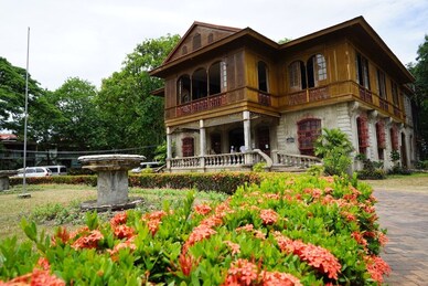
Bernardino-Jalandoni House (Museum) was built in 1908. It is a perfect example of the affluent Filipino house of the late 19th-early 20th century still influenced by the nipa hut, and built smack by the side of the street since motor vehicles were still non-existence to smog the place. All items on display are authentic period pieces. It is located at Rizal Street with Tel. No. 4955093. It is open Tuesday to Sunday from 10:00 a.m. to 6:00 p.m.
Hofileña Ancestral House, the first house in the city to be opened to visitors. It is the repository of the private art collection of Ramon H. Hofileña. The exhibit includes the work of top artists in the country.
Silay City Park is a garden complex that features a children’s park, a fountain, a basketball court, and a family lane. Back in 1951, the old Silay Plaza was adjudged the “Most Beautiful Plaza in the Philippines.”
Friendship Shrine is a memorial to the heroism of World War II veterans.
Cinco de Noviembre Marker is located on the site formerly occupied by the drug store of Leandro Locsin. The place served as the secret meeting place of the leaders of the 1898 revolution. A bloodless revolution against Spanish authority in Silay took place on November 5, 1898.
Patag Valley is 32 kilometers east of the city. It was the stronghold of Japanese Imperial Army in Negros during the Second World War. It features underground tunnels and war artifacts.
Patag Tourist Zone features the Patag Lantawan Bivoacs, sulfur springs, enchanted lakes, numerous waterfalls, skyline for cliff hangers, flora and fauna.
Silay Shooting Range at Hda. Luguay. This is designed to enhance Silay PNP capability and to promote responsible gun ownership. Related program covers police tourism.
Mangrove Canopy. It is a romantic promenade featuring mangrove conservation and a perfect view for sunset at the horizon.
Bagonita Ride offers tourists a galloping adventure at the railroad passing bangus ponds and mangrove areas.
Hometown Delicacy Barter Trade is situated at the west entrance of Silay Public Market #1. Delicacy makers spread these delights for snack sellers to be distributed in other town and cities.
Hda. Adela Forklore Village showcases traditional bilasyon, lowa, harana, luy-a, composo and other folk beliefs.
Nora Lacson House of Delicacies located at the corner of Rizal- McKinley streets. The house offers lumpia ubod, pili square, empanada and other family delights.
A Glimpse of SDO Silay City
The Schools Division of Silay City is a medium-sized division with 32 public kinder elementary schools, 15 public secondary schools, and 14 senior high schools. It has also 18 kinder private schools, 7 elementary private schools, 5 private Junior high schools and 4 private senior high schools.
Recently, the new Redistricting scheme was implemented, from six (6) school districts, the Schools Division of Silay City has now ten (10) school districts, each manned by a full-fledged Public Schools District Supervisor.
The Schools Division of Silay City’s mandates, powers and functions is anchored on the common dreams and aspirations of the whole organization clearly defined in the Vision, Mission and Core Values of the Department of Education. The vision and mission serve as a road map of the Division – where the division is going, whom the department wants to serve, what services the department can do and in what manner for which the service is done.
Adhering on the “Basic Education Sector Reform Agenda” or BESRA on its five key reform thrusts, the Division of Silay City gives emphasis on the improvement of school performance and learning outcomes; focuses on the improvement of learning outcomes by enhancement of teaching pedagogies and strategies which is geared towards development in basic education; desires to increase overall learning achievements by setting new standards in key learning areas; improving early childhood education and alternative learning systems; and to promote outcome focus and resource mobilization management thru the adoption of medium-term expenditure framework, full operationalization of organization’s performance indicators framework (OPIF) in planning, budgeting and reporting and strengthening of financial management system.
Moreover, the Division geared its performances and accomplishments on the three (3) thematic areas of concern: 1) Expanding Access to Basic Education; 2) Improving the Quality and Relevance of Basic Education; 3) and Improving Governance and Efficiency.
The performance of the Division is gauged through the internal efficiency level measured by the different performance indicators. Management of Educational Services is focused on the proper implementation of the Division’s Human, Material and Financial Resources to achieve efficient office operations and delivery of educational services to its clienteles. This year, the Division has been synergizing efforts to attain the set targets in line with stakeholders’ participation, personnel matters and financial management.
DIVISION SITUATIONAL OVERVIEW
The Situational Overview contains the socio-economic situation of the Province of Negros Occidental and Silay City. This section gives a short history and a brief account on geographical and sociological situations.
Alongside socio-economic conditions, this section also depicts the National thrusts and programs.
Negros Occidental, particularly is located in the western side of Negros Island, the fourth largest island in the Philippines with a total land area of 792,607 hectares or 7,926.06 sq. kms.
The province is approximately 375 kilometers long from north to south. It is bounded by the Visayan Sea in the north, Panay Gulf on the west, Tanon Strait and Negros Oriental province on the east and Sulu Sea on the south. Negros is basically volcanic, making its soil ideal for agriculture. Eighty percent of all arable land is cultivated.
Mount Kanlaon is one of the mountain ranges found in the heart of Negros Island. One of the country’s 13 most active volcanoes, Kanlaon is the highest peak in Central Philippines. At an elevation of 2,465 meters above sea level, the most dominant and attractive feature of which is its active summit-crater. Mt. Kanlaon has a land area of 24,577.6 hectares, with rainforest and verdant vegetation sliced from the cities of Bago, La Carlota, San Carlos and Canlaon (in Negros Oriental) and the towns of Murcia and La Castellana.
The trek through ridges and deep gorges for 14.5 kilometers shows a panorama of lowlands and carved mountains. An 8.5 kilometer ascent along sights of refreshing waterfalls and treacherous trails best capture the moods of this unpredictable volcano. Rare endemic species such as the Bleeding Heart Pigeon and the Negros Fruit Dove are protected in this park, which makes bird watching a prime attraction. Other birds include woodpeckers, bulbuls, babblers, warblers and flycatchers. The Guintubdan Nature Camp in La Carlota City is one of the best take-off points in climbing Mt. Kanlaon.
It is believed that Negros was once part of a greater mass of land but was cut off either by what geologists all a continental drift or by rising waters during the so-called glacial age. Among its earliest inhabitants were dark-skinned natives belonging to the Negrito ethnic group with their unique culture. Thus, the Spaniards called the land “Negros” after the black natives whom they saw when they first came to the island in April 1565. Two of the earliest native settlements were Binalbagan and Ilog, that later became towns in 1573 and 1584, respectively. Other settlements were Hinigaran, Bago, Marayo (now Pontevedra), Mamalan (now Himamaylan) and Candaguit (now a sitio in San Enrique).
After appointing encomenderos in the island, Miguel Lopez de Legaspi placed Negros under the jurisdiction of the governor of Oton in Panay. In 1734, however, the island became a military district and Ilog was made its first capital. The seat of government was later transferred to Himamaylan and thereafter Bacolod became the
Capital in 1849.
The island remained a military district up to about the middle of the 19th century. Then in 1865, Negros Occidental was raised to the category of a politico-military province. During this time, several more towns were established like San Carlos and Calatrava.
Religious orders evangelized the province by turns: the Augustinians, Recollects, Jesuits, Dominicans, Seculars and again, the Recollects returning in the 1800s.
The latter half of the 19th century was a period of rapid economic expansion for Negros Occidental as evidenced by the growth of population resulting from the influx of immigrants coming from neighboring provinces like Iloilo, Antique, Capiz and Cebu. They settled in districts sparsely inhabited in the past and this resulted in the establishments of new towns: Saravia (now E.B. Magalona), Valladolid and Escalante
In 1860.
The major boom to the province at this time was the widespread cultivation of sugarcane and the opening of ports like those in Iloilo and Cebu to foreign commerce. In 1856, Negros Occidental produced only 4,000 piculs of sugar. This increased to 100,000 piculs in 1864 and 2,000,000 in 1893. The cultivation of sugarcane then became widespread and soon after Negros Occidental led other provinces in the production of sugar. Modern machines were also introduced at this time and by 1864, seven machines operated by steam were used in the towns of Bacolod, Minuluan (now
Talisay and Bago).
During the last decade of the 19th century, several important events occurred in the history of Negros Occidental. One was the making of Negros Occidental as a separate province from Negros Oriental in 1890. The other was when Negrense revolutionary troops led by Generals Aniceto Lacson and Juan Araneta joined the nationwide-Katipunan Movement and overcame the Spanish garrison in the province on November 5, 1898 when the Filipinos rose in arms against the Spanish rule. The
revolt ended more than 300 years of foreign domination.
This resulted in the establishment of the short lived “Cantonal Government of the Republic of Negros” which reunited the two provinces until the Americans arrived in May 1899. A civil government was established in Negros Occidental on April 20, 1901.
During the succeeding decades between 1901 and the 1930s, Negros Occidental was under the American occupation as with the rest of the country. Nonetheless, the economic growth continued especially with Philippine sugar having a part of the US market despite some accompanying socio-economic problems during this period. When the Japanese landed in the province on May and instead organized a free government and guerilla movement under Gov. Alfredo Montelibano, Sr. in Negros Island. They helped bring about the surrender of the Japanese forces in Negros in 1945.The history of the province for the post World War II period has yet to be formally written. Suffice it to briefly note here that this was mainly a period of rehabilitation from the destruction of war. With the sugar industry, the major pillar of the province’s economy, as well as other areas being revived, consequent socio-
economic growth in the province followed.
The socio-economic life of Negros Occidental from the 1950s up to the 1980s depended as before mainly on the sugar industry. Producing annually about 60% of the country’s sugar output, an expansion in the industry with the establishment of several new mills in the late 1960s spurred increased production. A downturn caused by the low world sugar prices in the early 1980s was followed by possibly the worst industry and province-wide crisis starting in 1984 with the world sugar prices hitting rock bottom in 1985. The province was also hit by two destructive typhoons in 1984, Nitang and Undang, after a serious drought in 1983.
The year 1985 also marked the period when Negros Occidental became known throughout the country and abroad as suffering from historic socio-economic crisis. Various forms of international aid were sent to Negros and many Negrenses , national and foreign government and government organizations, responded in cooperation with the Philippine Government to help the province cope with the crisis.
While the country was simmering like a volcano that later erupted at EDSA in February 1986, Negros Occidental was split into two provinces after a plebiscite in Cadiz on January 3, 1986. Negros Occidental (mother province) was left with 3 cities and 18 municipalities while Negros del Norte (new province) had 3 cities and 8 municipalities starting from the City of Silay to the northern tip,San Carlos City, including the new town of Don Salvador Benedicto. The creation of this new province was, however, opposed by the Negros Anti-Partition Movement and the Supreme Court declared the creation unconstitutional on July 11, 1986. On August 18, 1986, Negros del Norte was formally returned to Negros Occidental, thus making the province whole again.
Toward the end of 1987, the rays of hope started to shine when the overall economic situation showed an upturn. The campaign for agricultural diversification had been gaining momentum, paving the way for more landowners to invest in prawn farming, livestock and high-value crops such as fruits, vegetables and other cash crops. Investments upswing became apparent by 1988. The participation of the industrial sector accelerated consumer economic growth and development manifested by the increase in sales of consumer goods and by-products.
However, just when the economic boom was beginning to seep in the overall economy of Negros Occidental brought about by the acceleration of various economic activities, the recurring ills of the sugar industry in the second half of the 1990’s slowed down the continuing economic uptrend of the province. Nevertheless, with the widespread benefits brought about by the positive changes in the socio-economic condition of the province by the 2000’s, clear sign of economic recovery for Negros Occidental is anticipated. (www.negros.occ.gov.ph/about-negros-occidental)
It has a total land area of 21,486 hectares and bounded on the west by Guimaras Strait, on the east by Marapara mountain ranges, on the north by the Municipality of E.B. Magalona and on the south by the City of Talisay. It is approximately 14.4 kilometers away from the Capital City of Negros Occidental, Bacolod City. It is considered a second class city with 115, 236 (2006 Projection) residents spread among its sixteen (16) barangays.
Founded in 1760, Silay evolved from being an old Spanish settlement. Migrant families from Iloilo gave vigor to Silay, making it an important commercial and agricultural settlement during the Spanish era. In 1846, cultivation of sugarcane led by Yves Leopold Germain Gaston made the town prosperous. November 5, 1898 played a significant role in Silay’s history. Sugarcane workers attacked the Spanish garrison and made the Spaniards surrender peacefully. It was a bloodless revolution. The Philippine flag was raised for the first time at the public plaza. Silay, famous for its artists and cultural shows, became the “Paris of Negros”. Kahirup Theater was the center of these activities. Jose “Pitong” Ledesma, a Silaynon pianist, conductor and philanthropist was one of those responsible for inviting operatta and zarzuela performers from Europe. (www.negros-occ.gov.ph/about-negros-occidental/cities-and-municipalities/cities/silay-city)
Silay City is a seat of famous landmarks which attract tourists. These are:
San Diego Pro-Cathedral is the only pro-cathedral outside of Metro Manila. The church has a dome that resembles St. Peter’s Basilica in Rome. It was built in 1920 & designed by Italian architect, Antonio Bernasconi.
31 Ancestral Houses identified by the National Historical Institute as cultural landmarks.
Steam Locomotives at Hawaiian Philippines Co. or known as “Iron Dinosaurs” are among the oldest in the world.
Balay Negrense is the ancestral mansion of the Gastons that was converted into a lifestyle museum showing how sugar planters lived at the beginning of the century. Museum is open from Tuesday to Sunday at 10:00 a.m to 6:00 p.m. Cinco de Noviembre Street Tel. No. 4954916.
Bernardino-Jalandoni House (Museum) was built in 1908. It is a perfect example of the affluent Filipino house of the late 19th-early 20th century still influenced by the nipa hut, and built smack by the side of the street since motor vehicles were still non-existence to smog the place. All items on display are authentic period pieces. It is located at Rizal Street with Tel. No. 4955093. It is open Tuesday to Sunday from 10:00 a.m. to 6:00 p.m.
Hofileña Ancestral House, the first house in the city to be opened to visitors. It is the repository of the private art collection of Ramon H. Hofileña. The exhibit includes the work of top artists in the country.
Silay City Park is a garden complex that features a children’s park, a fountain, a basketball court, and a family lane. Back in 1951, the old Silay Plaza was adjudged the “Most Beautiful Plaza in the Philippines.”
Friendship Shrine is a memorial to the heroism of World War II veterans.
Cinco de Noviembre Marker is located on the site formerly occupied by the drug store of Leandro Locsin. The place served as the secret meeting place of the leaders of the 1898 revolution. A bloodless revolution against Spanish authority in Silay took place on November 5, 1898.
Patag Valley is 32 kilometers east of the city. It was the stronghold of Japanese Imperial Army in Negros during the Second World War. It features underground tunnels and war artifacts.
Patag Tourist Zone features the Patag Lantawan Bivoacs, sulfur springs, enchanted lakes, numerous waterfalls, skyline for cliff hangers, flora and fauna.
Silay Shooting Range at Hda. Luguay. This is designed to enhance Silay PNP capability and to promote responsible gun ownership. Related program covers police tourism.
Mangrove Canopy. It is a romantic promenade featuring mangrove conservation and a perfect view for sunset at the horizon.
Bagonita Ride offers tourists a galloping adventure at the railroad passing bangus ponds and mangrove areas.
Hometown Delicacy Barter Trade is situated at the west entrance of Silay Public Market #1. Delicacy makers spread these delights for snack sellers to be distributed in other town and cities.
Hda. Adela Forklore Village showcases traditional bilasyon, lowa, harana, luy-a, composo and other folk beliefs.
Nora Lacson House of Delicacies located at the corner of Rizal- McKinley streets. The house offers lumpia ubod, pili square, empanada and other family delights.
For over 200 years of existence the City of Silay is very proud of its rich heritage. Silay City is known as the “Paris of Negros”, the “lap of virgin forests”, “City of 300 waterfalls”, “last stand of the Japanese imperial army”, and the unchallenged “seat of arts, culture and eco-tourism”. It is recognized by the Department of Tourism as one of the top destinations in the Philippines being the site of an airport of international standard.
It has a total land area of 21,486 hectares and bounded on the west by Guimaras Strait, on the east by Marapara mountain ranges, on the north by the Municipality of E.B. Magalona and on the south by the City of Talisay. It is approximately 14.4 kilometers away from the Capital City of Negros Occidental, Bacolod City. It is considered a second class city with 115, 236 (2006 Projection) residents spread among its sixteen (16) barangays.
Founded in 1760, Silay evolved from being an old Spanish settlement. Migrant families from Iloilo gave vigor to Silay, making it an important commercial and agricultural settlement during the Spanish era. In 1846, cultivation of sugarcane led by Yves Leopold Germain Gaston made the town prosperous. November 5, 1898 played a significant role in Silay’s history. Sugarcane workers attacked the Spanish garrison and made the Spaniards surrender peacefully. It was a bloodless revolution. The Philippine flag was raised for the first time at the public plaza. Silay, famous for its artists and cultural shows, became the “Paris of Negros”. Kahirup Theater was the center of these activities. Jose “Pitong” Ledesma, a Silaynon pianist, conductor and philanthropist was one of those responsible for inviting operatta and zarzuela performers from Europe. (www.negros-occ.gov.ph/about-negros-occidental/cities-and-municipalities/cities/silay-city).
Silay City is a seat of famous landmarks which attract tourists. These are:
San Diego Pro-Cathedral is the only pro-cathedral outside of Metro Manila. The church has a dome that resembles St. Peter’s Basilica in Rome. It was built in 1920 & designed by Italian architect, Antonio Bernasconi.
31 Ancestral Houses identified by the National Historical Institute as cultural landmarks
Steam Locomotives at Hawaiian Philippines Co. or known as “Iron Dinosaurs” are among the oldest in the world.
Balay Negrense is the ancestral mansion of the Gastons that was converted into a lifestyle museum showing how sugar planters lived at the beginning of the century. Museum is open from Tuesday to Sunday at 10:00 a.m to 6:00 p.m. Cinco de Noviembre Street Tel. No. 4954916.
Bernardino-Jalandoni House (Museum) was built in 1908. It is a perfect example of the affluent Filipino house of the late 19th-early 20th century still influenced by the nipa hut, and built smack by the side of the street since motor vehicles were still non-existence to smog the place. All items on display are authentic period pieces. It is located at Rizal Street with Tel. No. 4955093. It is open Tuesday to Sunday from 10:00 a.m. to 6:00 p.m.
Hofileña Ancestral House, the first house in the city to be opened to visitors. It is the repository of the private art collection of Ramon H. Hofileña. The exhibit includes the work of top artists in the country.
Silay City Park is a garden complex that features a children’s park, a fountain, a basketball court, and a family lane. Back in 1951, the old Silay Plaza was adjudged the “Most Beautiful Plaza in the Philippines.”
Friendship Shrine is a memorial to the heroism of World War II veterans.
Cinco de Noviembre Marker is located on the site formerly occupied by the drug store of Leandro Locsin. The place served as the secret meeting place of the leaders of the 1898 revolution. A bloodless revolution against Spanish authority in Silay took place on November 5, 1898.
Patag Valley is 32 kilometers east of the city. It was the stronghold of Japanese Imperial Army in Negros during the Second World War. It features underground tunnels and war artifacts.
Patag Tourist Zone features the Patag Lantawan Bivoacs, sulfur springs, enchanted lakes, numerous waterfalls, skyline for cliff hangers, flora and fauna.
Silay Shooting Range at Hda. Luguay. This is designed to enhance Silay PNP capability and to promote responsible gun ownership. Related program covers police tourism.
Mangrove Canopy. It is a romantic promenade featuring mangrove conservation and a perfect view for sunset at the horizon.
Bagonita Ride offers tourists a galloping adventure at the railroad passing bangus ponds and mangrove areas.
Hometown Delicacy Barter Trade is situated at the west entrance of Silay Public Market #1. Delicacy makers spread these delights for snack sellers to be distributed in other town and cities.
Hda. Adela Forklore Village showcases traditional bilasyon, lowa, harana, luy-a, composo and other folk beliefs.
Nora Lacson House of Delicacies located at the corner of Rizal- McKinley streets. The house offers lumpia ubod, pili square, empanada and other family delights.
A Glimpse of SDO Silay City
The Schools Division of Silay City is a medium-sized division with 32 public kinder elementary schools, 15 public secondary schools, and 14 senior high schools. It has also 18 kinder private schools, 7 elementary private schools, 5 private Junior high schools and 4 private senior high schools.
Recently, the new Redistricting scheme was implemented, from six (6) school districts, the Schools Division of Silay City has now ten (10) school districts, each manned by a full-fledged Public Schools District Supervisor.
The Schools Division of Silay City’s mandates, powers and functions is anchored on the common dreams and aspirations of the whole organization clearly defined in the Vision, Mission and Core Values of the Department of Education. The vision and mission serve as a road map of the Division – where the division is going, whom the department wants to serve, what services the department can do and in what manner for which the service is done.
Adhering on the “Basic Education Sector Reform Agenda” or BESRA on its five key reform thrusts, the Division of Silay City gives emphasis on the improvement of school performance and learning outcomes; focuses on the improvement of learning outcomes by enhancement of teaching pedagogies and strategies which is geared towards development in basic education; desires to increase overall learning achievements by setting new standards in key learning areas; improving early childhood education and alternative learning systems; and to promote outcome focus and resource mobilization management thru the adoption of medium-term expenditure framework, full operationalization of organization’s performance indicators framework (OPIF) in planning, budgeting and reporting and strengthening of financial management system.
Moreover, the Division geared its performances and accomplishments on the three (3) thematic areas of concern: 1) Expanding Access to Basic Education; 2) Improving the Quality and Relevance of Basic Education; 3) and Improving Governance and Efficiency.
The performance of the Division is gauged through the internal efficiency level measured by the different performance indicators. Management of Educational Services is focused on the proper implementation of the Division’s Human, Material and Financial Resources to achieve efficient office operations and delivery of educational services to its clienteles. This year, the Division has been synergizing efforts to attain the set targets in line with stakeholders’ participation, personnel matters and financial management.
DIVISION SITUATIONAL OVERVIEW
The Situational Overview contains the socio-economic situation of the Province of Negros Occidental and Silay City. This section gives a short history and a brief account on geographical and sociological situations.
Alongside socio-economic conditions, this section also depicts the National thrusts and programs.
- History and Overview of Socio-Economic Status of the Province of Negros Occidental
Negros Occidental, particularly is located in the western side of Negros Island, the fourth largest island in the Philippines with a total land area of 792,607 hectares or 7,926.06 sq. kms.
The province is approximately 375 kilometers long from north to south. It is bounded by the Visayan Sea in the north, Panay Gulf on the west, Tanon Strait and Negros Oriental province on the east and Sulu Sea on the south. Negros is basically volcanic, making its soil ideal for agriculture. Eighty percent of all arable land is cultivated.
Mount Kanlaon is one of the mountain ranges found in the heart of Negros Island. One of the country’s 13 most active volcanoes, Kanlaon is the highest peak in Central Philippines. At an elevation of 2,465 meters above sea level, the most dominant and attractive feature of which is its active summit-crater. Mt. Kanlaon has a land area of 24,577.6 hectares, with rainforest and verdant vegetation sliced from the cities of Bago, La Carlota, San Carlos and Canlaon (in Negros Oriental) and the towns of Murcia and La Castellana.
The trek through ridges and deep gorges for 14.5 kilometers shows a panorama of lowlands and carved mountains. An 8.5 kilometer ascent along sights of refreshing waterfalls and treacherous trails best capture the moods of this unpredictable volcano. Rare endemic species such as the Bleeding Heart Pigeon and the Negros Fruit Dove are protected in this park, which makes bird watching a prime attraction. Other birds include woodpeckers, bulbuls, babblers, warblers and flycatchers. The Guintubdan Nature Camp in La Carlota City is one of the best take-off points in climbing Mt. Kanlaon.
It is believed that Negros was once part of a greater mass of land but was cut off either by what geologists all a continental drift or by rising waters during the so-called glacial age. Among its earliest inhabitants were dark-skinned natives belonging to the Negrito ethnic group with their unique culture. Thus, the Spaniards called the land “Negros” after the black natives whom they saw when they first came to the island in April 1565. Two of the earliest native settlements were Binalbagan and Ilog, that later became towns in 1573 and 1584, respectively. Other settlements were Hinigaran, Bago, Marayo (now Pontevedra), Mamalan (now Himamaylan) and Candaguit (now a sitio in San Enrique).
After appointing encomenderos in the island, Miguel Lopez de Legaspi placed Negros under the jurisdiction of the governor of Oton in Panay. In 1734, however, the island became a military district and Ilog was made its first capital. The seat of government was later transferred to Himamaylan and thereafter Bacolod became the
Capital in 1849.
The island remained a military district up to about the middle of the 19th century. Then in 1865, Negros Occidental was raised to the category of a politico-military province. During this time, several more towns were established like San Carlos and Calatrava.
Religious orders evangelized the province by turns: the Augustinians, Recollects, Jesuits, Dominicans, Seculars and again, the Recollects returning in the 1800s.
The latter half of the 19th century was a period of rapid economic expansion for Negros Occidental as evidenced by the growth of population resulting from the influx of immigrants coming from neighboring provinces like Iloilo, Antique, Capiz and Cebu. They settled in districts sparsely inhabited in the past and this resulted in the establishments of new towns: Saravia (now E.B. Magalona), Valladolid and Escalante
In 1860.
The major boom to the province at this time was the widespread cultivation of sugarcane and the opening of ports like those in Iloilo and Cebu to foreign commerce. In 1856, Negros Occidental produced only 4,000 piculs of sugar. This increased to 100,000 piculs in 1864 and 2,000,000 in 1893. The cultivation of sugarcane then became widespread and soon after Negros Occidental led other provinces in the production of sugar. Modern machines were also introduced at this time and by 1864, seven machines operated by steam were used in the towns of Bacolod, Minuluan (now
Talisay and Bago).
During the last decade of the 19th century, several important events occurred in the history of Negros Occidental. One was the making of Negros Occidental as a separate province from Negros Oriental in 1890. The other was when Negrense revolutionary troops led by Generals Aniceto Lacson and Juan Araneta joined the nationwide-Katipunan Movement and overcame the Spanish garrison in the province on November 5, 1898 when the Filipinos rose in arms against the Spanish rule. The
revolt ended more than 300 years of foreign domination.
This resulted in the establishment of the short lived “Cantonal Government of the Republic of Negros” which reunited the two provinces until the Americans arrived in May 1899. A civil government was established in Negros Occidental on April 20, 1901.
During the succeeding decades between 1901 and the 1930s, Negros Occidental was under the American occupation as with the rest of the country. Nonetheless, the economic growth continued especially with Philippine sugar having a part of the US market despite some accompanying socio-economic problems during this period. When the Japanese landed in the province on May and instead organized a free government and guerilla movement under Gov. Alfredo Montelibano, Sr. in Negros Island. They helped bring about the surrender of the Japanese forces in Negros in 1945.The history of the province for the post World War II period has yet to be formally written. Suffice it to briefly note here that this was mainly a period of rehabilitation from the destruction of war. With the sugar industry, the major pillar of the province’s economy, as well as other areas being revived, consequent socio-
economic growth in the province followed.
The socio-economic life of Negros Occidental from the 1950s up to the 1980s depended as before mainly on the sugar industry. Producing annually about 60% of the country’s sugar output, an expansion in the industry with the establishment of several new mills in the late 1960s spurred increased production. A downturn caused by the low world sugar prices in the early 1980s was followed by possibly the worst industry and province-wide crisis starting in 1984 with the world sugar prices hitting rock bottom in 1985. The province was also hit by two destructive typhoons in 1984, Nitang and Undang, after a serious drought in 1983.
The year 1985 also marked the period when Negros Occidental became known throughout the country and abroad as suffering from historic socio-economic crisis. Various forms of international aid were sent to Negros and many Negrenses , national and foreign government and government organizations, responded in cooperation with the Philippine Government to help the province cope with the crisis.
While the country was simmering like a volcano that later erupted at EDSA in February 1986, Negros Occidental was split into two provinces after a plebiscite in Cadiz on January 3, 1986. Negros Occidental (mother province) was left with 3 cities and 18 municipalities while Negros del Norte (new province) had 3 cities and 8 municipalities starting from the City of Silay to the northern tip,San Carlos City, including the new town of Don Salvador Benedicto. The creation of this new province was, however, opposed by the Negros Anti-Partition Movement and the Supreme Court declared the creation unconstitutional on July 11, 1986. On August 18, 1986, Negros del Norte was formally returned to Negros Occidental, thus making the province whole again.
Toward the end of 1987, the rays of hope started to shine when the overall economic situation showed an upturn. The campaign for agricultural diversification had been gaining momentum, paving the way for more landowners to invest in prawn farming, livestock and high-value crops such as fruits, vegetables and other cash crops. Investments upswing became apparent by 1988. The participation of the industrial sector accelerated consumer economic growth and development manifested by the increase in sales of consumer goods and by-products.
However, just when the economic boom was beginning to seep in the overall economy of Negros Occidental brought about by the acceleration of various economic activities, the recurring ills of the sugar industry in the second half of the 1990’s slowed down the continuing economic uptrend of the province. Nevertheless, with the widespread benefits brought about by the positive changes in the socio-economic condition of the province by the 2000’s, clear sign of economic recovery for Negros Occidental is anticipated. (www.negros.occ.gov.ph/about-negros-occidental)
- Brief History and Overview of the Socio-Economic Status of Silay City
It has a total land area of 21,486 hectares and bounded on the west by Guimaras Strait, on the east by Marapara mountain ranges, on the north by the Municipality of E.B. Magalona and on the south by the City of Talisay. It is approximately 14.4 kilometers away from the Capital City of Negros Occidental, Bacolod City. It is considered a second class city with 115, 236 (2006 Projection) residents spread among its sixteen (16) barangays.
Founded in 1760, Silay evolved from being an old Spanish settlement. Migrant families from Iloilo gave vigor to Silay, making it an important commercial and agricultural settlement during the Spanish era. In 1846, cultivation of sugarcane led by Yves Leopold Germain Gaston made the town prosperous. November 5, 1898 played a significant role in Silay’s history. Sugarcane workers attacked the Spanish garrison and made the Spaniards surrender peacefully. It was a bloodless revolution. The Philippine flag was raised for the first time at the public plaza. Silay, famous for its artists and cultural shows, became the “Paris of Negros”. Kahirup Theater was the center of these activities. Jose “Pitong” Ledesma, a Silaynon pianist, conductor and philanthropist was one of those responsible for inviting operatta and zarzuela performers from Europe. (www.negros-occ.gov.ph/about-negros-occidental/cities-and-municipalities/cities/silay-city)
Silay City is a seat of famous landmarks which attract tourists. These are:
San Diego Pro-Cathedral is the only pro-cathedral outside of Metro Manila. The church has a dome that resembles St. Peter’s Basilica in Rome. It was built in 1920 & designed by Italian architect, Antonio Bernasconi.
31 Ancestral Houses identified by the National Historical Institute as cultural landmarks.
Steam Locomotives at Hawaiian Philippines Co. or known as “Iron Dinosaurs” are among the oldest in the world.
Balay Negrense is the ancestral mansion of the Gastons that was converted into a lifestyle museum showing how sugar planters lived at the beginning of the century. Museum is open from Tuesday to Sunday at 10:00 a.m to 6:00 p.m. Cinco de Noviembre Street Tel. No. 4954916.
Bernardino-Jalandoni House (Museum) was built in 1908. It is a perfect example of the affluent Filipino house of the late 19th-early 20th century still influenced by the nipa hut, and built smack by the side of the street since motor vehicles were still non-existence to smog the place. All items on display are authentic period pieces. It is located at Rizal Street with Tel. No. 4955093. It is open Tuesday to Sunday from 10:00 a.m. to 6:00 p.m.
Hofileña Ancestral House, the first house in the city to be opened to visitors. It is the repository of the private art collection of Ramon H. Hofileña. The exhibit includes the work of top artists in the country.
Silay City Park is a garden complex that features a children’s park, a fountain, a basketball court, and a family lane. Back in 1951, the old Silay Plaza was adjudged the “Most Beautiful Plaza in the Philippines.”
Friendship Shrine is a memorial to the heroism of World War II veterans.
Cinco de Noviembre Marker is located on the site formerly occupied by the drug store of Leandro Locsin. The place served as the secret meeting place of the leaders of the 1898 revolution. A bloodless revolution against Spanish authority in Silay took place on November 5, 1898.
Patag Valley is 32 kilometers east of the city. It was the stronghold of Japanese Imperial Army in Negros during the Second World War. It features underground tunnels and war artifacts.
Patag Tourist Zone features the Patag Lantawan Bivoacs, sulfur springs, enchanted lakes, numerous waterfalls, skyline for cliff hangers, flora and fauna.
Silay Shooting Range at Hda. Luguay. This is designed to enhance Silay PNP capability and to promote responsible gun ownership. Related program covers police tourism.
Mangrove Canopy. It is a romantic promenade featuring mangrove conservation and a perfect view for sunset at the horizon.
Bagonita Ride offers tourists a galloping adventure at the railroad passing bangus ponds and mangrove areas.
Hometown Delicacy Barter Trade is situated at the west entrance of Silay Public Market #1. Delicacy makers spread these delights for snack sellers to be distributed in other town and cities.
Hda. Adela Forklore Village showcases traditional bilasyon, lowa, harana, luy-a, composo and other folk beliefs.
Nora Lacson House of Delicacies located at the corner of Rizal- McKinley streets. The house offers lumpia ubod, pili square, empanada and other family delights.
